Image credit: ‘The Isthmus of Auckland’ — map from Geological and Topographical Atlas of New Zealand by Dr Ferdinand von Hochstetter and Dr A. Petermann, 1864. Ref: Mantell HOC 1864 (Acc-868-008-mm) Alexander Turnbull Library.
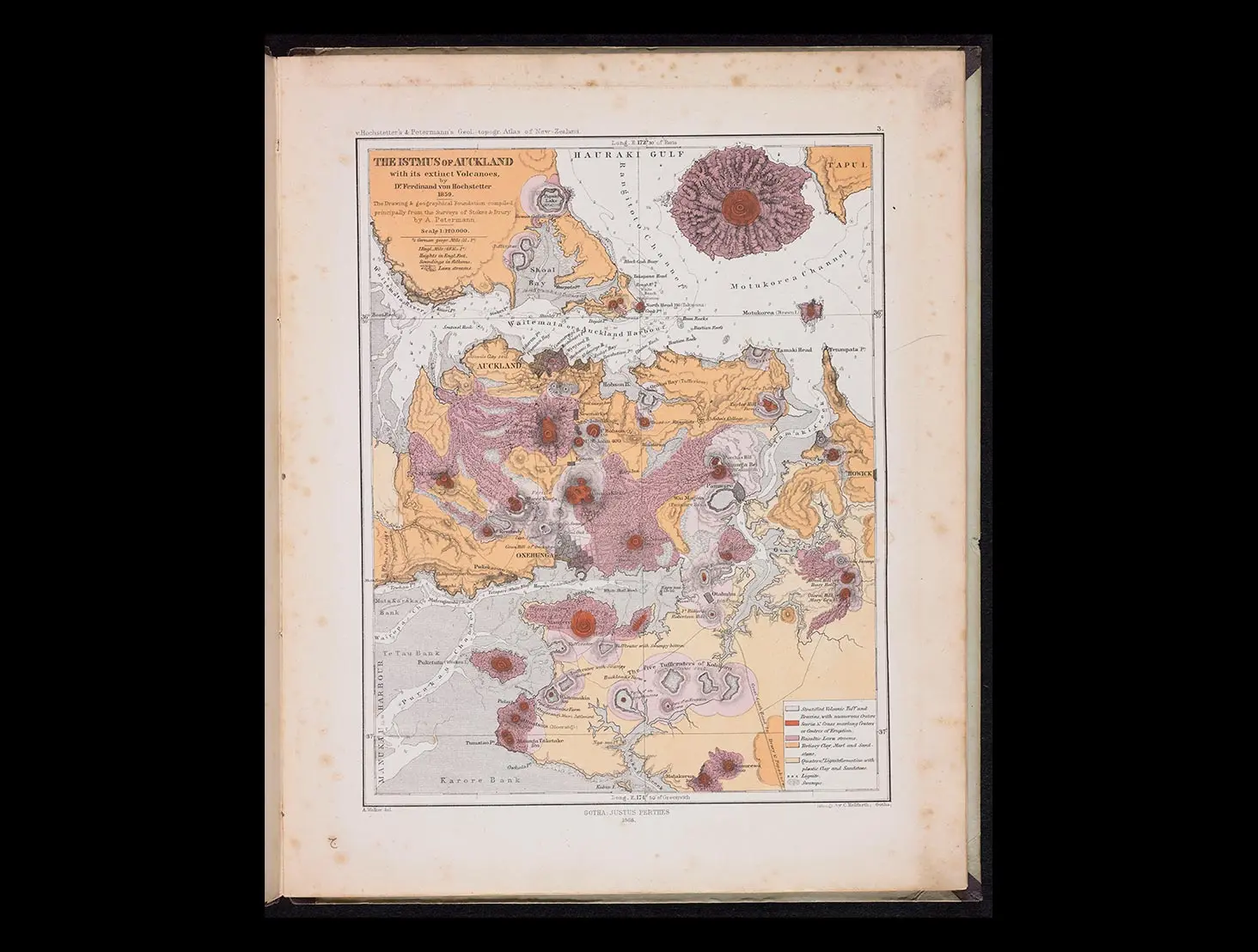
Image credit: ‘The Isthmus of Auckland’ — map from Geological and Topographical Atlas of New Zealand by Dr Ferdinand von Hochstetter and Dr A. Petermann, 1864. Ref: Mantell HOC 1864 (Acc-868-008-mm) Alexander Turnbull Library.
Aotearoa New Zealand’s first atlas (published in 1864) was created from a geological and topographical survey carried out by the German scientist Ferdinand von Hochstetter. Find out more, and explore our collections and curated resources.
German scientist Ferdinand von Hochstetter (1829–1884) spent much of 1859 travelling around Aotearoa surveying its varied geology. He arrived in Auckland in December 1858 as a member of the Austrian Novara scientific expedition. Soon after, the Auckland provincial government invited him to make an extended stay to carry out a geological survey and explore mineral resources. The task was also a topographical survey, as the land beyond the coast had not yet been mapped in any detail.
Initially, Hochstetter surveyed the Auckland volcanic field, visiting many of the points of eruption and working closely with the artist Charles Heaphy (1820–1881), who provided tracings of base maps. The resulting map forms an important record of the Auckland landscape before it was altered by extensive quarrying and development in the burgeoning urban area.
Once Hochstetter had investigated the surroundings of Auckland, he undertook a major 79-day survey expedition across the North Island, travelling from Auckland down to Lake Taupō and up through Rotorua and the Bay of Plenty, before returning to Auckland. A geological highlight of this journey was the visit to Lake Rotomahana, which resulted in Hochstetter’s iconic map showing the location of the Pink and White Terraces, Ōtūkapuarangi and Te Tarata, a major tourist attraction before it was obliterated by the Mount Tarawera eruption of 10 June 1886.
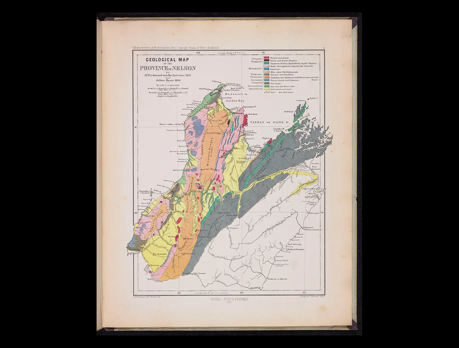
Later, Hochstetter and his friend and newly arrived migrant the geologist Julius von Haast (1822–1887) went on to explore parts of Nelson Province, where gold, copper, coal and various minerals were being mined.
After returning to Vienna in 1860, Hochstetter compiled a folio of the survey observations that were scattered throughout his diary and sent this data to the pre-eminent cartographer of the day, August Petermann, in Gotha, Germany. Petermann and a team at the Justus Perthes publishing house brought together Hochstetter’s extensive fieldwork, including the compass bearings, drawings, photographs and sketch maps he had created on site.
The six chromolithographic printed maps that emerged were first produced with German-language labels and published in journals, books and the German edition of the atlas. They formed a unique portrait of the land. The English version of the maps was commissioned by Carl Frank Fischer of Auckland, who compiled the atlas, which was then published by his brother-in-law Theodore DeLattre in 1864 as the first atlas of New Zealand.
Story written by: Sascha Nolden
Copyright: Turnbull Endowment Trust
Image credit: ‘Rotomahana or the Warm Lake’ — map from Geological and Topographical Atlas of New Zealand by Dr Ferdinand von Hochstetter and Dr A. Petermann, 1864. Ref: Mantell HOC 1864 (Acc-868-010-mm) Alexander Turnbull Library.
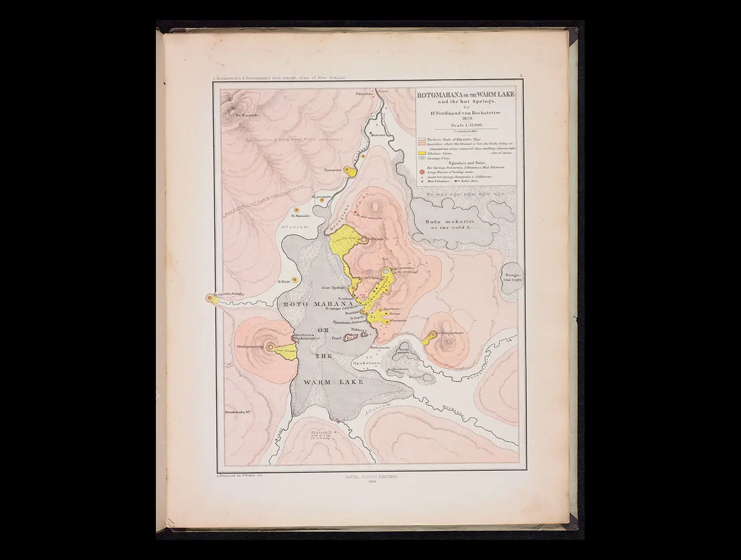
Image credit: ‘Geological Map of the Province of Nelson’ — map from Geological and Topographical Atlas of New Zealand by Dr Ferdinand von Hochstetter and Dr A. Petermann, 1864. Ref: Mantell HOC 1864 (Acc-868-011-mm) Alexander Turnbull Library.
Read a connected story from Te Kupenga: Aotearoa from the air.
Explore the Alexander Turnbull Library collections further:
Topic Explorer has:
Many Answers has Mountains.
Want to share, print or reuse one of our images? Read the guidelines for reusing Alexander Turnbull Library images.
Tikanga ā-iwi:
Te whakaritenga pāpori me te ahurea
Te ao hurihuri
Ngā mahinga ohaoha.
Te Takanga o Te Wā (ngā hītori o Aotearoa):
Whakapapa
Tūrangawaewae.
Social sciences concepts:
Identity, culture, and organisation
Place and environment
Continuity and change
The economic world.
Aotearoa New Zealand’s histories:
Colonisation and its consequences.